About Us
Nicholas Bugosh is the inventor of a new approach to land grading that returns disturbed lands to natural function and appearance that is known as GeoFluv™. In 2009, he formed the company GeoFluv to provide training, coaching, and consulting services in this innovative landform design method. The GeoFluv approach forms the heart of the Carlson Software Natural Regrade module that was released in 2005. Nicholas is also presently the GeoFluv™ Technical Director for Carlson Software.
He resides in Parma, Ohio and is responsible for the development and promotion of the Natural Regrade fluvial geomorphic landform design computer software module worldwide. Natural Regrade is used across the United States, in Canada, South America, Australia, and Europe.
The GeoFluv approach forms the heart of the Carlson Software Natural Regrade module
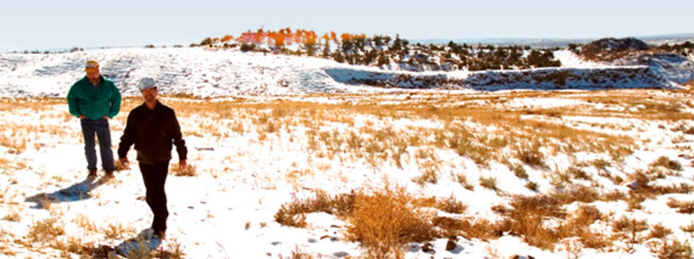
Nicholas’ training in geology and hydrology includes Bachelor of Science in Geology and Master of Science in Earth Sciences. He has conducted field research on bedload transportation in mountain streams, worked for state agencies in South Dakota, Montana, and Idaho with mining and water quality regulation, worked as a hydrologic consultant on projects across the United States, and worked as Senior Hydrologist for the New Mexico operations of the largest mining company in the world.
Bugosh, N. and E.G. Epp, 2019. Evaluating Sediment Production from Native and Fluvial Geomorphic-Reclamation Watersheds at La Plata Mine, Catena, 174 (2019) 383-398.
Hancock, G.R.,Martín Duque, J.F.and Willgoose, G.R., 2018. Geomorphic design and modelling at catchment scale for best mine rehabilitation–The Drayton mine example (New South Wales, Australia), Environmental Modelling and Software 114 (2019) 140–151. https://doi.org/10.1016/j.envsoft.2018.12.003
Zapico, et al., 2018, Geomorphic reclamation for reestablishment of landform stability at a watershed scale in mined sites: The Alto Tajo Natural Park, Spain. Ecological Engineering, Volume 111, February 2018, Pages 100–116
Zhang, Z.F., Bugosh, N., et al, June 2018. Conceptual Model for Hydrology-Based Geomorphic Evapotranspiration Covers for Reclamation of Mine Land in Arid Climates in proceedings of the 2018 National Meeting of the American Society of Mining and Reclamation, St Louis, MO: The Gateway to Land Reclamation. June 2-7, 2018. Published by ASMR, 1305 Weathervane Dr. Champaign, IL 61821.
Bugosh, N., Martín Duque, J.F., Eckels, R. 2016. The GeoFluv Method for Mining Reclamation: Why and How it is Applicable to Closure Plans in Chile. In: Planning for Closure 2016, First International Congress on Planning for Closure of Mining, Wiertz, J., Priscu, D. (Eds.), Gecamin, Santiago de Chile.
Duque, J.F.M., Bugosh, N., et al, 2015. Examples of geomorphic reclamation on mined lands in Spain by using the GeoFluv method, Geophysical Research Abstracts Vol. 17, U2015-2895, 2015 EGU General Assembly 2015 © Author(s) 2015. CC Attribution 3.0 License.
Bugosh, N., Duque, J.F.M. and R. Eckels, 2014. Evaluating Sediment Production from Reclamation Designed Using the GeoFluv Fluvial Geomorphic Method presented at NAAMLP 36th Annual Conference, 22 September 2014, Columbus, Ohio.
Bugosh, N. and E. Epp, 2014. Evaluating Sediment Production from Watersheds at La Plata Mine presented at Advances in Geomorphic Reclamation at Coal Mines, Office of Surface Mining Technical Interactive Forum and Field Tour, 20-22 May 2014, Albuquerque, NM.
Duque, J.F.M. and N. Bugosh, 2014. Examples of Geomorphic Reclamation on Mined Lands in Spain, from Pioneering Cases to the Use of the GeoFluvTM Method presented at Advances in Geomorphic Reclamation at Coal Mines, Office of Surface Mining Technical Interactive Forum and Field Tour, 20-22 May 2014, Albuquerque, NM.
Duque, J. F. M. and N. Bugosh, 2012. Remodeling the Ground in the Ecological Restoration Area Affected by Mining Activities: the Use of Geomorphological Criteria in the GeoFluv Method in Scientific-Technical Conference on Ecological Restoration in areas affected by mining, Ponferrada, Spain, 8- 11 May 2012, Energy City, CIUDEN (in press)
Bugosh, Nicholas, 2009. A Summary of Some Land Surface and Water Quality Monitoring Results for Constructed GeoFluv Landforms, presented at 26th Annual American Society of Mining and Reclamation Meeting and 11th Billings Land Reclamation Symposium, 28 May – 5 June 2009, Billings MT and jointly published by BLRS and ASMR, R.I. Barnhisel (ed.) 3134 Montavesta Rd., Lexington, KY 40502.
Bugosh, Nicholas, 2009. Can Appalachian Mine Reclamation Be Called Sustainable Using Current Practices? presented at Office of Surface Mining Technical Interactive Forum on Geomorphic Reclamation and Natural Stream Design, Bristol, Virginia.
Bugosh, Nicholas, 2008. The Importance of Fluvial Geomorphic Landform Characteristics to Ensuring Stability Against Erosion and Their Use in Landform Design, presented at 30th Annual Conference of the National Association of Abandoned Mine Land Programs, “From Four Corners to All Corners: Connecting for Reclamation”– Durango, Colorado, 26-29 October 2008.
Bugosh, Nicholas, 2008. Erosion Control without Erosion Controls, in Sustainable Land Development Today, January 2008.
Measles, David and Nicholas Bugosh, 2007. MAKING AND BUILDING A FLUVIAL GEOMORPHIC RECLAMATION DESIGN AT AN ACTIVE DRAGLINE MINE USING THE GEOFLUVTM DESIGN METHOD in Joint Conference of the 24th Annual Meetings of the American Society of Mining and Reclamation, Gillette, Wyoming, 2-7 June 2007, p.4, Published by ASMR, 3134 Montavesta Rd., Lexington, KY 40502.
Bugosh, Nicholas, 2006. A Primer to the GeoFluvTM Method for Reclamation Landform Design (using Natural Regrade software to design and evaluate landforms), presented at National Interactive Forum on Geomorphic Reclamation, “Putting a New Face on Mining Reclamation”, A National Interactive Forum on Geomorphic Reclamation, Farmington, New Mexico, 12 September 2006. Published by U.S. Department of the Interior, Office of Surface Mining, Office of Technology Transfer.
Bugosh, Nicholas, 2006. REGIONAL VARIATION IN STABLE LANDFORMS-And How Critical Elements Can Be Used To Design Reclamation Landforms presented at 2006 Billings Land Reclamation Symposium, June 4-8, 2006, Billings MT and jointly published by BLRS and ASMR, R.I. Barnhisel (ed.) 3134 Montavesta Rd., Lexington, KY 40502.
Carlson Software, Inc. and Bugosh, Nicholas, FLUVIAL GEOMORPHIC LANDSCAPE DESIGN COMPUTER SOFTWARE, U.S. Patent Office, publication number WO/2005/036331, international application number PCT/US2004/02995.
Bugosh, Nicholas and Eckels, Rod, 2006. Restoring Erosional Features in the Desert; New Landform Design Software and Automated Machine Guidance Combine in Award-Winning Reclamation Project in Coal Age, March 2006, Vol. 111, No. 3., 3 pp.
Bugosh, Nicholas, 2004 – Computerizing the Fluvial Geomorphic Approach to Land Reclamation presented at the 2004 National Meeting of the American Society of Mining and Reclamation and The 25th West Virginia Surface Mine Drainage Task Force, April 18-24, 2004, Morgantown, West Virginia. Published by ASMR, 3134 Montavesta Rd., Lexington, KY 40502.
June 2019. Lessons About Geomorphic Reclamation from Sediment Yield Quantification and Erosion Modeling Studies at ASMR 2019 Annual Conference, Big Sky, Montana.
June 2019. Modeling Water Balance of Geomorphic Evapotranspiration Covers for Reclamation of Mine Land at ASMR 2019 Annual Conference, Big Sky, Montana.
September 2018. Landform Design And Modelling For Best Practise In Mine Rehabilitation at Complutense International Course (C.I.C.), Faculty of Geology, Complutense University of Madrid, Spain.
June 2018. Conceptual Model for Hydrology-Based Geomorphic Evapotranspiration Covers for Reclamation of Mine Land in Arid Climates at the 2018 National Meeting of the American Society of Mining and Reclamation, St Louis, MO: The Gateway to Land Reclamation. June 2-7, 2018. Published by ASMR, 1305 Weathervane Dr. Champaign, IL 61821.
September 2015. Evaluating Sediment Production from Native and Fluvial Geomorphic Reclamation Watersheds at La Plata Mine and its Relationship to Local Precipitation Events at NAAMLP 37th Annual Conference, Santa Fe, New Mexico.
September 2014, Evaluating Sediment Production from Reclamation Designed Using the GeoFluv Fluvial Geomorphic Method at NAAMLP 36th Annual Conference, Columbus, Ohio.
May 2014, Evaluating Sediment Production from Watersheds at La Plata Mine at Advances in Geomorphic Reclamation at Coal Mines, Office of Surface Mining Technical Interactive Forum and Field Tour, Albuquerque, NM.
May 2014, Examples of Geomorphic Reclamation on Mined Lands in Spain, from Pioneering Cases to the Use of the GeoFluvTM Method at Advances in Geomorphic Reclamation at Coal Mines, Office of Surface Mining Technical Interactive Forum and Field Tour, Albuquerque, NM.
April 2013, First Results of a Study of Measured Sediment Yield from Constructed GeoFluv Landforms and Adjacent Native Land at Environmental Considerations in Energy Production, Charleston, WV
October 2011, Sediment Yield from Constructed GeoFluv Landforms and Adjacent Native Land, at 2011 NAAMLP National Conference, Lake Tahoe, Nevada
September 2010, Lessons Learned from the Last Decade of GeoFluv Fluvial Geomorphic Reclamation, at 2010 NAAMLP Annual Meeting, Scranton, PA
June 2010, Using Fluvial Geomorphic Design to Meet Community Reclamation Expectations at 2010 ASMR Annual Meeting, Pittsburgh, PA
March 2010, A Comparison of Field-Verified GeoFluv Landform Erosion Stability to Predicted Erosion from a Computerized Erosion Prediction Model, at 2010 SME Annual Meeting, Phoenix, Arizona.
November 2009, How GeoFluv Designs Can Provide Reclamation Land Use Sustainability, web-based class at Alaska Miner’s Conference, Anchorage, Alaska
April 2009, Natural Regrade, Providing Land Use Sustainability, at Carlson User Conference
Lexington, Kentucky
February 2009, The GeoFluvTM Method for Reclamation Landform Design (Using Natural Regrade Software to Design and Evaluate Landforms for Sustainable Land Uses) at 2009 SME Annual Meeting Denver, Colorado.
January 2008, The GeoFluvTM approach to designing stable reclamation landforms (a possible answer to mitigation) at West Virginia Coal Conference, Charleston, West Virginia.
March 2008, The GeoFluvTM approach to designing stable reclamation landforms at Tennessee Mining Conference, Gatlinburg, Tennessee.
December 2007, The GeoFluvTM approach to designing stable reclamation landforms (Natural Regrade case histories) at GeoFluv seminar, Elko, Nevada.
September 2007 – The GeoFluvTM approach to designing stable reclamation landforms (Natural Regrade case histories) at Southern Ute Growth Fund, Durango, Colorado.
September 2007 – The GeoFluvTM Approach to Designing Stable Reclamation Landforms (Natural Regrade case histories), at National Association of State Land Reclamationists, Asheville, North Carolina.
September 2006 – A Primer to the GeoFluvtm Method for Reclamation Landform Design; Using Natural Regrade Software to Design and Evaluate Landforms, at National Interactive Forum on Fluvial Geomorphic Reclamation, Farmington, New Mexico.
August 2006 – Regional Variation in Stable Landforms – and how critical elements can be used to design reclamation landforms, at 31st Annual Meeting and Conference, Canadian Land Reclamation Association, Ottawa, Canada.
June 2006 – Introduction to Natural Regrade Training, taught short course at joint American Society for Mine Reclamation / Billings Reclamation Symposium, Billings, Montana.
June 2006 – Regional Variation in Stable Landforms – and how critical elements can be used to design reclamation landforms, at joint American Society for Mine Reclamation / Billings Reclamation Symposium, Billings, Montana.
June 2006 – Machine Guidance – Bringing Complex Designs to the Field, with Tim Kerr (Leica Geosystems), at joint American Society for Mine Reclamation / Billings Reclamation Symposium, Billings, Montana.
April 2006 – Landform Design for Mine Disturbed Land: Constructing Landforms That Function Like Natural Systems, taught fluvial geomorphic short course with Les Sawatsky (Golder Assoc.) at Montana Tech ‘Mine Design, Operations, and Closure’ conference, Anaconda, Montana.
September 2005 – Using advanced computer software to integrate desktop computational power, CAD design, and GPS guided machine control to design and build functional, maintenance-free, and cost effective reclamation landforms – theory, practice and case history at New Technologies Implementation Information Workshop, Sheridan, WY.
April 2005 – Using Natural Regrade’s GeoFluvTM Approach to Overcome Reclamation Grading and Landform Stability Problems with Mining-Disturbed Land at Montana Tech ‘Mine Design, Operations, and Closure’ conference, Polson, Montana.
December 2004 – Carlson Software’s Natural Regrade Module: Computerizing the Fluvial Geomorphic Approach to Land Reclamation at OSM Geospatial Technology Conference, Atlanta, Georgia.
July 2003 – Innovative Reclamation Techniques at San Juan Coal Company (or why we are doing our reclamation differently), at Rocky Mountain Coal Mining Institute national meeting, Copper Mt., Colorado.
June 2003 – Stream Channel Design Reclamation – The Fluvial Geomorphic Approach to Hydrologic Reclamation, taught pre-conference workshop at joint conference of the Billings land Reclamation Symposium and the Annual Meeting of the American Society of Mining and Reclamation, Billings, MT. (Participants represented OSM, CO, MT, NM, NO, SO, TX, WY, USFS, Peabody, Kennecott, and consulting companies.)
August 2001 – Fluvial Geomorphic Reclamation at Office of Surface Mining Bond Release Forum, Bismarck, ND.
August 2001 – Innovative Reclamation Practices at San Juan Coal Company, NM at Office of Surface Mining Bond Release Forum, Bismarck, ND.
January 2000 – Fluvial Geomorphic Principles Applied to Mined land Reclamation at OSM Alternatives to Gradient Terraces Workshop, Farmington, NM.
During his graduate study on bedload transport, he discovered that accepted design methods based on theoretical relationships can produce results that do not agree with observed natural processes (Field verification of predictive bedload formulas in high gradient mountain streams, Masters Thesis, MSU, 1986). Discussions at an American Geomorphological Field Group meeting in 1982 that was hosted by Luna Leopold confirmed to Nicholas that other workers who were active in the field, as well as in the laboratory, were also concluding that accepted methods did not always agree with natural processes. This experience strongly influenced him to observe, measure, and analyze natural processes.
When Nicholas began his professional career working on water quality and land reclamation problems, he was surprised to see how far accepted methods diverged from natural hydrologic principles. In general, the accepted methods viewed flowing water as the problem and sought to control erosion and sedimentation by using various means, e.g., gradient terraces, large-size rock channel linings (“rip-rap”), drop structures, etc., to reduce the discharge velocity. He noted during stream and storm water sampling events that natural landforms without these sorts of features were capable of conveying extreme storms without excessive erosion and sedimentation. These observations led to analyses of the essential features that defined stable landforms.
The next step was to develop a methodology to design stable landforms that used measurements of these essential features taken from stable reference landforms near the project area as inputs to the design. The resulting method has been named GeoFluv™, adapted from ‘fluvial geomorphology’, which is literally landforms made by the process of flowing water. The method caught widespread attention when its use was demonstrated for coal mine reclamation, but it is effective for any land-disturbing activity.
GeoFluv is a particular patented method, adaptable to computer aided design, for designing landforms that will convey runoff water the way a natural landform would. Nicholas joined Carlson Software in 2003 to make the GeoFluv method into a user-friendly software program, which was released in May 2005. This website describes the GeoFluv training, Natural Regrade Software, GeoFluv design services, and gives examples of applications to various kinds of projects. It also has references and links to GeoFluv Associates that are successfully using and representing the GeoFluv method internationally.
Thank you for visiting GeoFluv.com!
GeoFluv™ vs the Traditional Approach

GeoFluv Approach
Traditional Method
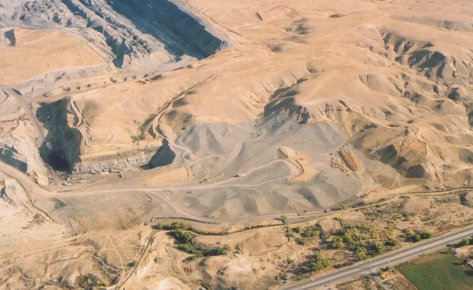
GeoFluv creates a natural looking landscape with ridges that transition from convex to concave slopes, small sub-watersheds containing water channels that merge into larger water channels that are designed with the required cross sectional profile and sinuosity to handle variable flows. No artificial contour banks and rock drains required.
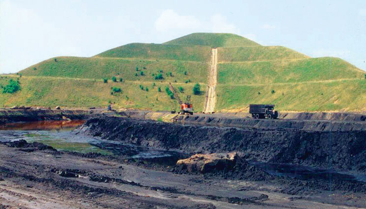
Long, single gradient slopes that are subject to erosion. A range of techniques are employed to slow erosion including contour banks, rock drains and sediment ponds.
GeoFluv appears as a natural landscape.
Appears as flat topped pyramids – with a number of rock down-drains.
GeoFluv makes a stable landform that does not require long term maintenance.
Requires long term maintenance.
GeoFluv landscape variability promotes biodiversity – as the landscape has varying aspects and slope.
Difficult to establish bio-diversity on slopes of single gradient and orientation.
GeoFluv needs to be built with GPS guided machines.
Does not require GPS guided earth-moving machines for construction.
GeoFluv water run-off in surrounding streams meets environmental requirements.
Water run-off into surrounding streams often turbid and saline.
Rod Eckels is an Australian surveyor who has been involved in GPS surveying since 1984. From 1987 -2006 Rod worked for Leica GeoSystems in a rnage of training, sales, support and management roles. In January 1997, Rod moved to Torrance, California where his product management responsibilities were to find new applications for Leica’s high dynamic GPS receivers – including Machine Control. In this role, Rod worked closely with Carlson Software who were developing the user interface and CAD software for some of Leica’s range of machine guidance products.
Rod met Nicholas Bugosh in 2003 working on mine reclamation activities at La Plata mine, where Nicholas was applying GeoFluv principles to the reclamation design and Leica was providing the Machine Guidance capability. Rod saw that the GeoFluv solution for landform design combined with the new capabilities of Machine Control provided a excellent solution for a long standing reclamation problem.
In 2006 Rod returned to Australia and started a range of activities, including lecturing at the Uni NSW in Surveying and consulting activities.
Rod started Landforma in 2009 to promote and support the GeoFluv approach in Australia.
Jose Francisco Martin Duque, is a Spanish professor on the faculty of Geological Sciences at the Universidad Complutense (UCM) in Madrid, Spain.
Jose met Nicholas Bugosh in 2009 when Jose asked Nicholas to provide peer review for his project-update paper about a geomorphic-based land reclamation project that he had designed and constructed in Spain. Nicholas participated in Jose’s November 2009 UCM seminar and explained the GeoFluv method. Jose introduced a Masters level course in 2010 that incorporated the GeoFluv design method using Natural Regrade. Since then Jose’s students have used the GeoFluv method and Natural Regrade in their Masters theses and PhD dissertations.
In 2014 Jose started knowledge-transfer university group Restauracion Geomorfologica to provide GeoFluv method training services. He collaborates with scholars internationally and has authored professional papers about GeoFluv and supports users in western Europe and Spanish-speaking areas in Central- and South America.
Eugene Schutte is the Principal of Mining Resource Consultants (MRC) based in Ermelo, South Africa. Eugene has over 34 years of experience in the mining industry in both opencast and underground. His portfolio ranges from risk assessment, to operations management, to corporate mine management, to mining engineering and more. Having worked in coal, base metals, nickel, gold, and zinc, Eugene possesses a diverse knowledge of functions and systems.
Nicholas Bugosh provided Eugene with in-the-field training in South Africa in 2018 for methods to collect the site-specific fluvial geomorphic reference area landform characteristics that are Natural Regrade input values. They applied the input values to make alternative reclamation designs for a South African coal mine site.
Eugene became a GeoFluv Associate in 2019 and he promotes and supports the GeoFluv approach for all of Africa.
See how Geofluv™ creates a natural looking landscape with ridges that transition from convex to concave slopes, small sub-watersheds containing water channels that merge into larger water channels that are designed with the required cross sectional profile and sinuosity to handle variable flows. No artificial contour banks and rock drains required.
The GeoFluv™ approach recognises the critical importance of natural landforms as the basis for successful land rehabilitation.
Natural landforms have developed over thousands of years through the action of water and erosion. They are considered “stable” as their changing form is imperceptible.
The GeoFluv™ approach incorporates the key landscape characteristics of a site to design a surface that functions exactly the same as the stable landforms that surround it.
It is a process that compresses 1000’s of years of earth shaping forces into a design, resulting in a “stable” landscape.
These landforms have demonstrated to provide erosion rates similar to natural undisturbed lands and will be suitable for re-establishing local flora and fauna and will not require costly long-term maintenance.
GeoFluv™ landform designs are not only functional – coping with the complete range of rainfall and water discharge events that may occur, they result in natural “looking” landscapes that are pleasing to the eye and well accepted in the community.